촬영지블로그컬렉션검색문의

구루시마 해협 대교

에히메현· Kurushima-Kaikyo Bridge

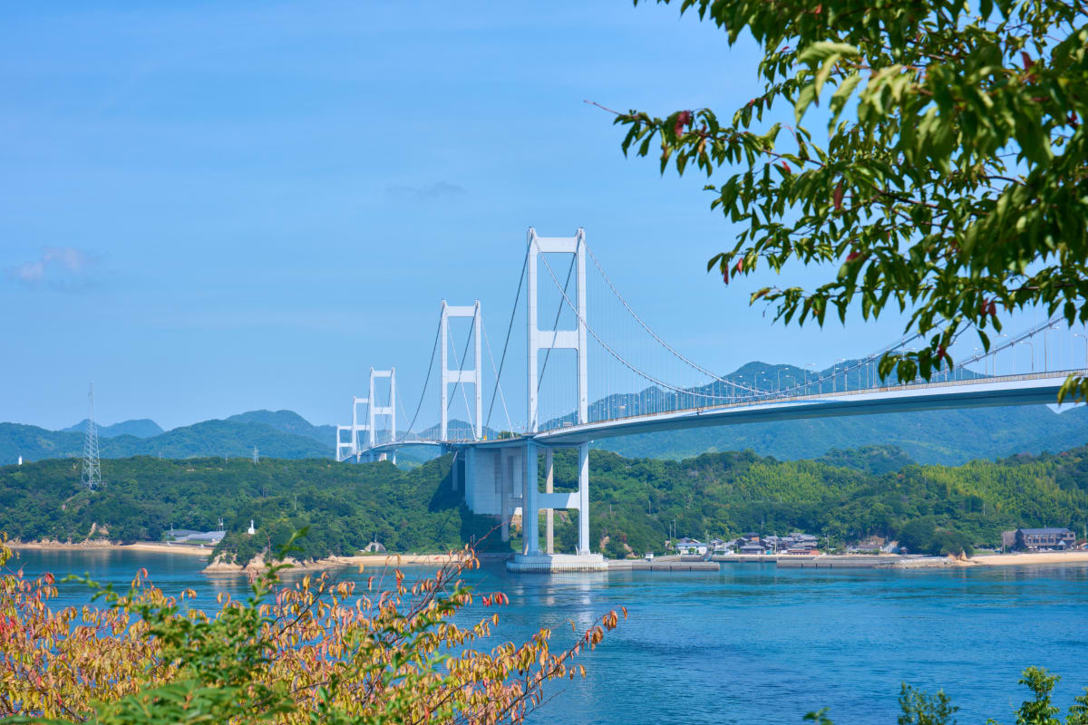
The Kurushima-Kaikyo Bridge connects Imabari City in Ehime Prefecture to Oshima Island across the Kurushima Strait — a three-in-a-row suspension bridge with a total length of 4,105 m. It opened in May 1999 with the completion of the Honshu-Shikoku Onomichi-Imabari route (Shimanami Kaido), as the world's first three-section suspension bridge. The first (960 m), second (1,515 m), and third (1,570 m) suspension structures connect in distinctive sequence; beneath them flow currents of up to 10 knots in the Kurushima Strait — one of Japan's three great fast-current straits. With a bicycle and pedestrian path along the deck, Shimanami Kaido is a globally renowned cycling route, and the views from Mt. Kiro Observatory and Itoyama Park form the Inland Sea's most dramatic compositions.

하이라이트

  • Three-section suspension structure — a world-first sequence of First, Second, and Third bridges, totaling 4,105 m and slicing across the strait in a straight line
  • View from Mt. Kiro Observatory — at 307 m, a 360° panorama of the entire bridge, the strait, and surrounding islands; spectacular at sunset
  • Itoyama Park (Imabari side) — a park beside the bridge's foot, where the slanting late-day light and the shimmering surface combine beautifully
  • Cycling deck — a 6.5 km cycling path on top of the bridge, riding 70 m above the sea — the symbol of the Shimanami Kaido route
  • Fast strait currents — up to 10 knots beneath the bridge, with whitecaps and eddies that animate the shot

빠른 답변

What is the Kurushima-Kaikyo Bridge?
A 4,105 m three-section suspension bridge connecting Imabari (Ehime) to Oshima Island, opened in 1999 with the completion of the Shimanami Kaido — the world's first three-section suspension structure. With its bicycle and pedestrian path, it has become the symbol of one of the world's premier cycling routes.
Best spot to photograph the bridge?
Mt. Kiro Observatory (Oshima, Imabari) provides the definitive overview. Capture both the orange-lit bridge at sunset and the blue hour afterward. Itoyama Park puts you near the bridge's foot, and the cycling deck offers an in-flight view 70 m above the sea.
Access and cycling information?
About 30 minutes by car from Imabari Station to Mt. Kiro Observatory. By bike, it's about 20 km from Imabari Port (rental bikes available) to the bridge. Riding the entire 70 km Shimanami Kaido takes one day for casual riders or half a day for fast cyclists.
Toll for crossing by car?
Imabari IC to Oshima-Minami IC is ¥1,000 for standard cars (¥800 with ETC). The bridge has a bicycle/pedestrian deck — vehicles use the central lanes. Bicycle/pedestrian was free until April 2024, when bicycles became ¥100 (pedestrians remain free). Cycling the 5 km takes 15–20 minutes of nonstop spectacle.
When to see the tidal currents?
The Kurushima Strait is one of Japan's three great tidal currents, with up to 10 knots driven by the level gap between the Inland Sea and Hiuchi-nada. Shoot within ±1 hour of peak tides — whitecaps and whirlpools at their most dramatic. Mt. Kiro Observatory captures bridge and currents in one frame, especially during spring and autumn ohshio (great tides).
Other nearby attractions?
①Itoyama Park (under the bridge, low-angle drama) ②Yoshiumi Rose Park (May, roses + bridge) ③Oshima Stone Quarry Ruins (white rock walls) ④Yoshiumi Iki-iki Kan (seafood with bridge view dining) ⑤Murakami Suigun Museum (medieval pirate culture). A 1–2 day stay covers the bridge from many angles.
구루시마 해협 대교 - 에히메현 | Landscapes of Japan
2025
Landscapes of Japan

More in 에히메현

기로산 전망대
1 photos
마쓰야마성
4 photos
도고 온천
4 photos

Related Content

Collections & Tags
해안

Other prefectures in Shikoku

도쿠시마현(2)가가와현(2)고치현(11)
View all 47 prefectures →